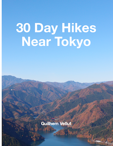
Companion website of the book "30 Day Hikes Near Tokyo"
Content
Book sample
 Download a
PDF
with 5 hikes from the book
Download a
PDF
with 5 hikes from the book
Book pages on Amazon
General resources
Online maps
Online, the most useful map for hiking in Japan is probably the one from GSI (Geospatial Information Authority of Japan).
It can be accessed at maps.gsi.go.jp.
Some introductory instructions are available on this
page. The full PDF manual is here.
By default, a topographic map with labels in Japanese (淡色地図) is shown but it can be changed to other
background layers by clicking the button on the top left :
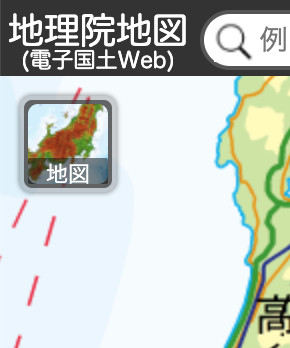
Then you can switch to an English map (but it doesn't zoom in very low) or an aerial photo view (写真). There
are also plenty of other data to display.
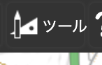
It is also possible to add the KMLs for each hike (that you can download below). To do that, follow those
steps:
- Click on the tool icon in the top right.
- Then in the popup on the right, click on the annotation/file icon.
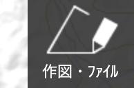
- Open the KML selection dialog by clicking on the folder icon in the top left of the new popup.

- Choose your KML files (multiple selection possible) then click on the OK button.
- The new files will be listed on the top right and will be displayed on the map. You will have to zoom in
yourself though. With the ..._steps.kml KML file (corresponding to the numbered steps in the Course
paragraphs of the book), the icons on the map can be clicked on and the step numbers will be displayed.
- To remove a KML, click the Delete button in the list. Note that simply reloading the page will remove
all the KMLs at once.

It is also possible to print (including the KML, if it has been added), although a sufficiently detailed map
will probably take more than a single A4 page. To do that, click on the Print button (印刷) in the menu on the
upper right corner of the screen. You can choose the paper format (landscape or portrait, A4 or A3) and also
adjust the extent of the map. Then click on the 印刷 button: Depending on the OS, you can save the map as PDF
instead of printing. Finally, click on the 元の画面に戻る button to go back to the interactive map.
Outside the GSI map, you can also use:
- OpenStreetMap: A community map
- OpenTopoMap: OpenStreetMap data (not
updated as often as the main OSM site) but with elevation on top and GPX import
- Google Maps: For satellite
images and 3D and for looking up transportation details
- Google
Earth: For 3D and importing KML
Paper maps
You can find a discussion on what paper map to purchase from this page (on the Ridgeline
Images blog). Basically, there are 2 main choices of paper maps: GSI (Geospatial Information
Authority of Japan) or Yama to Kogen Chizu.
Websites with hiking guides
You can find many more hikes as well as more info on some of the hikes featured in the book on the following
websites:
- Ridgeline Images: This is a blog in English that is regularly
updated. There are plenty of detailed hiking itineraries around Tokyo, which are listed on this page. Most of the hikes are
single day but there are also longer trails. Pretty much all of them are accessible with public
transport. There are also interesting resources regarding maps, equipment and advice on hiking in Japan.
Here are some pages that might be of interest:
- Hiking around Tokyo: This is another blog in English, also
regularly updated. The site contains mostly hiking guides / reports, with most of the hikes accessible
using public transport (sometimes a taxi). This page has useful advice:
- Yamareco: A community website in Japanese for hiking guides and
reports. Usually, the guides and reports are quite detailed with a map and a lot of photos (including
the signs). The trail descriptions also include the waypoints (blue squares on the maps or listed in the
hike descriptions), with a link to more photos and additional hikes that go through them. Yamareco can
be useful to check out recent hike reports to learn about the trail condition (for example, snow in
early spring). However, it is only in Japanese, including searching: You will have to copy paste the
kanji versions of the summits or landmarks to find anything. You will also have to disable your ad
blocker to access the hikes and for some of the hike reports, you will have to create an account just to
view (however, the links to Yamareco on this page should work fine withoug logging in). There are mostly
hiking (walking) guides but also sometimes running: The walking guides are indicated with a ハイキング label
- My blog in English (no longer
updated when it comes to Tokyo hikes)
Transportation
Kanji cheat sheet
From the Ridgeline Images blog (see above), Hiking Kanji Cheat
Sheet, a downloadable PDF of Japanese hiking terms that can be useful on the trails.
Hikes
For each hike, I have included:
- A link to the GSI map centered on the hike. To see all the details, including smaller trails and all the
contour lines, you will have to zoom in a little. To visualize the actual course featured in the book,
you will need to upload the KMLs yourselves since it is not possible for me to upload them then share
the map with you.
- Links to Google Maps with a search for direction. I have set the starting and returning points to
Shinjuku, but depending on where you stay, you can easily change that in the UI. You will also have to
change the time (correct day + change the hour to some time in the morning for the "Getting there" and
in the evening for "Coming back"). When the transportation needs a boat, unfortunately, Google Maps does
not support it: I have included the Google Maps direction search to the bus stop or train station
nearest to the boat terminal then included a link to the schedule of the boat company.
- KML and GPX files. They can be imported in the GSI map viewer or Google Earth or a dedicated hiking
mobile app. For more advanced use, they can also be imported in a GIS software like QGIS or ArcGIS (for
example if you want to do your own map and annotate).
- Links to alternative descriptions for the trail. Sometimes, the links describe the same trail as the
book but with different details, sometimes they describe a different itinerary (like the Alternate
section in the book), for example a shorter or longer version or with a different endpoint / starting
point or in reverse.
- Links to photos taken on the trail. Sometimes, it is the exact same course, but sometimes it is in the
reverse direction or from another hike that overlaps.
- A PDF with just the text of the hike as featured in the book. It can be useful for copy pasting the
kanji for searching in Google or Yamareco or to bring with you on the trail so you have a reference
withouth having to take the book with you.
- Other useful links (like a link to the bus or boat company).
If something is missing, let me know.
Download the
KML, GPX and course PDF for all the hikes (single ZIP).
1. Mount Takao & Lake Sagami / 高尾山~相模湖
GSI map
Directions
KML & GPX
Alternative descriptions
There are many of them, since Mount Takao is the most popular mountain near Tokyo.
Photos
Course PDF
Links
2. Mount Jinba & Mount Takao / 陣馬山~高尾山
GSI map
Directions
KML & GPX
Alternative descriptions
Photos
Course PDF
Links
3. Mount Arashi & Mount Sekiro / 嵐山~石老山
GSI map
Directions
KML & GPX
Alternative descriptions
Photos
Course PDF
4. Mount Shoto & Mount Jinba / 生藤山~陣馬山
GSI map
Directions
KML & GPX
Alternative descriptions
Photos
Course PDF
5. Mount Ogi & Mount Momokura / 扇山~百蔵山
GSI map
Directions
KML & GPX
Alternative descriptions
Photos
Course PDF
Links
6. Mount Takahata & Mount Kuratake / 高畑山~倉岳山
GSI map
Directions
KML & GPX
Alternative descriptions
Photos
Course PDF
7. Mount Mitsutoge / 三ツ峠山
GSI map
Directions
KML & GPX
Alternative descriptions
Photos
Course PDF
Links
8. Lake Kawaguchi, Mount Ashiwada & Aokigahara Forest / 河口湖~足和田山~青木ヶ原
GSI map
Directions
KML & GPX
Alternative descriptions
Photos
Course PDF
Links
9. Hakone: Mount Kami, Mount Komagatake & Hakone Old Road / 神山~駒ヶ岳~箱根旧街道
GSI map
Directions
KML & GPX
Alternative descriptions
Photos
Course PDF
Links
10. Lake Ashi (Outer-rim Trail) / 芦ノ湖 (外輪山ハイキングコース)
GSI map
Directions
KML & GPX
Alternative descriptions
Photos
Course PDF
Links
11. Yugawara: Mount Shiro, Mount Maku & Mount Nango / 城山~幕山~南郷山
GSI map
Directions
KML & GPX
Alternative descriptions
Photos
Course PDF
Links
12. Mount Oyama / 大山
GSI map
Directions
KML & GPX
Alternative descriptions
Photos
Course PDF
13. Mount Tonodake, Mount Tanzawa & Mount Sannoto / 塔ノ岳~丹沢山~三ノ塔
GSI map
Directions
KML & GPX
Alternative descriptions
Photos
Course PDF
14. Kamakura: Gionyama, Tenen & Daibutsu Hiking Trails / 鎌倉・祇園山~天園~大仏ハイキングコース
GSI map
Directions
KML & GPX
Alternative descriptions
Photos
Course PDF
Links
15. Mount Mihara & Izu Oshima / 三原山~伊豆大島
GSI map
Directions
KML & GPX
Alternative descriptions
Photos
Course PDF
Links
16. Mount Nokogiri & Nihon-ji Temple / 鋸山~日本寺
GSI map
Directions
KML & GPX
Alternative descriptions
Photos
Course PDF
Links
17. Mount Sengenrei, Mount Mito & Tomin-no-Mori Forest / 浅間嶺~三頭山~都民の森
GSI map
Directions
KML & GPX
Alternative descriptions
Photos
Course PDF
Links
18. Mount Hinode & Mount Mitake / 日の出山~御岳山
GSI map
Directions
KML & GPX
Alternative descriptions
Photos
Course PDF
Links
19. Otama Walking Trail / 大多摩ウォーキングトレイル
GSI map
Directions
KML & GPX
Alternative descriptions
Photos
Course PDF
Links
20. Mount Bonomine & Mount Iwatakeishi / 棒ノ嶺~岩茸石山
GSI map
Directions
KML & GPX
Alternative descriptions
Photos
Course PDF
Links
21. Mount Otake & Mount Mitake / 大岳山~御岳山
GSI map
Directions
KML & GPX
Alternative descriptions
Photos
Course PDF
Links
22. Okutama Mukashi Michi (Old Okutama Road) / 奥多摩むかし道
GSI map
Directions
KML & GPX
Alternative descriptions
Photos
Course PDF
Links
23. Mount Takanosu / 鷹ノ巣山
GSI map
Directions
KML & GPX
Alternative descriptions
Photos
Course PDF
Links
24. Mount Gozen & Mount Tsukiyomi / 御前山~月夜見山
GSI map
Directions
KML & GPX
Alternative descriptions
Photos
Course PDF
Links
- Website of Yama-no-Furusato Mura - Contains some information (in
the Blog update information / ブログ更新情報 panel) on the closure of the Mugiyama floating bridge /
麦山の浮橋
25. Mount Mito & Mount Odera / 三頭山~大寺山
GSI map
Directions
KML & GPX
Alternative descriptions
Photos
Course PDF
Links
26. Mount Kumotori / 雲取山
GSI map
Directions
KML & GPX
Alternative descriptions
Photos
Course PDF
27. Mount Buko / 武甲山
GSI map
Directions
KML & GPX
Alternative descriptions
Photos
Course PDF
Links
28. Nikko: Chanokidaira, Lake Chuzenji & Senjogahara Marshland / 茶ノ木平~中禅寺湖~戦場ヶ原
GSI map
Directions
KML & GPX
Alternative descriptions
Photos
Course PDF
Links
29. Mount Nyoho / 女峰山
GSI map
Directions
KML & GPX
Alternative descriptions
Photos
Course PDF
Links
30. Mount Tsukuba / 筑波山
GSI map
Directions
KML & GPX
Alternative descriptions
Photos
Course PDF
Links
Contact
For suggestions or corrections, please contact me at: contact+pub@vellut.com
Last update: September 17th 2020
My other books
